The main objective of URBAG is to evaluate which combinations of urban/peri-urban agriculture and green spaces result in the best performance in terms of these local and global environmental impacts. To do so, the following research questions and objectives are defined:
About the project
Urban and peri-urban agriculture is currently experiencing rapid growth. This covers a variety of forms, such as vertical farming, greenhouse rooftops, local foodsheds, which together with green spaces like parks and green roofs, are referred to as green infrastructure. It potentially makes cities more resilient to climate change and more sustainable in terms of water management, food production, air quality, human well-being and biodiversity. URBAG will examine if and how green infrastructure can be effective in contributing to sustainability in the aforementioned sense.

The innovation of the project lies in integrating the life cycle impacts of the resources required for green infrastructures with an understanding of how those green infrastructures impact the urban atmosphere interactions. Often various types of green infrastructures are promoted equally in urban sustainability agendas, without existing studies clearly indicating the effectiveness of one or another better serving sustainability goals of the city, such as reducing greenhouse gas emissions, improving local air quality, and optimizing its use of resources. Hence, this project will evaluate which combinations of urban/peri-urban agriculture and green spaces result in the best performance in terms of these local and global environmental impacts.
Funded by the European Union. Views and opinions expressed are however those of the author(s) only and do not necessarily reflect those of the European Union or the European Research Council. Neither the European Union nor the granting authority can be held responsible for them.
| Partial Research Question | Research Objectives |
| RQ1. What is the potential of urban food production in terms of the resources available in cities? | RO1. To assess the potential of optimizing urban/peri urban agri-culture and vegetation in terms of nutrient, water, and energy, con-sidering urban morphology and weather as well as life cycle impacts. |
| RQ2. What combinations of green infrastructures result in best performance in terms of air quality, temperature, and the carbon footprint of the city? | RO2. To analyze the direct and indirect effects of vegetation and urban agriculture on the urban and regional atmosphere. |
| RQ3. How can the growth in urban food production and green spaces be managed to enhance urban sustainability and avoid unintended consequences? | RO3. To provide urban planners and policy makers with the guidance and tools to create green infrastructure strategies to help meet sustainability targets, avoid unintended environmental conse-quences, and promote wider and diffused social benefits. |
This project is inspired by the pressing need to understand the effect of green infrastructures on the food-energy-water system and the urban atmosphere. Its innovative aspect is to integrate life cycle modelling that quantifies the metabolism of materials and energy associated to green infrastructures with atmospheric modelling to understand how those green infrastructures also affect the urban atmosphere. To do so, this project will implement a new approach in which land and resource use are used to drive both life cycle analysis and atmospheric modelling. Two case study cities and their metropolitan area will serve to develop this novel approach: Barcelona (Spain) and Oslo (Norway).
| Metropolitan Area of Barcelona | Oslo-Baerum-Nittedal | |
| Total km² | 636 | 830 |
| Built (%) | 34 | 18 |
| Green (%) | 31 | 65 |
| Agricultural (%) | 23 | 8 |
| Wetlands (%) | 0.72 | 4.6 |
| Population | 3.5 million | 0.8 million |
| Waste/cap (Kg) | 452 | 433 |
| Wastewater/cap/day (L) | 250 | 550 |
| Green infraestructura policy | Programme for Promoting Urban Green Infrastructures | Urban Ecology Programme 2011-2026 |
| Urban Policy | Urban Master Plan of Barcelona (Pla Director Urbanístic Metropolità de Barcelona) | Oslo’s Municipal Master Plan (Kommuneplan for Oslo) |
Based on the characteristics of the city, the URBAG team will create an innovative, geo-referenced land-use model to optimize urban and peri-urban food production in terms of nutrients, water, and energy, considering urban morphology and determining life cycle impacts (RQ1/RO1, Work Package 1). These optimized scenarios will be simulated with atmospheric models to determine the direct and indirect effects on the urban and regional atmosphere in terms of air quality, temperature, and greenhouse gases (RQ2/RO2, Work Package 2). This project will give city planners and policy makers the guidance to determine how the growth in urban food production and green spaces can be managed to enhance urban sustainability, avoid unintended environmental consequences, and promote wider and diffused social benefits (RQ3/RO3, Work Package 3).
Based on the premise that discovering sustainable solutions to the world’s most pressing problems requires systems-based approaches that integrate knowledge across multiple disciplines8, URBAG will take urban sustainability research into a new direction, aiming for a more integrated, systems-approach assessment than has been done up to now. The investigation will connect processes between the natural, socio-institutional, and the built environment, and is innovative in its multidisciplinary approach linking atmosphere science, agronomy, industrial ecology, and urban planning and policy.
The investigation, connecting processes between the natural, the socio-institutional, and the built environment, is innovative in its multidisciplinary approach, and will deliver the following innovative interconnected project results:
| Innovation | Question/Objective |
| Life cycle assessment of nutrient and water recovery to promote food production in cities. | RQ1/RO1 |
| A geo-referenced land-use model to optimize urban and peri-urban food production in terms of nutrients, water, and energy, considering urban morphology and determining life cycle impacts. | RQ1/RO1 |
| A spatial disaggregation approach based on land-use and/or local climate zone information to increase the resolution of emissions. | RQ2/RO2 |
| A spatially-temporally resolved framework for quantitative analysis and simulation of green infrastructures to determine the direct and indirect effects on the urban and regional atmosphere. | RQ2/RO2 |
| A method for quantifying the contribution of green infrastructures to the carbon footprint of the city. | RQ2/RO2 |
| An integrated systemic approach combining life cycle analysis and atmospheric modeling. | RQ3/RO3 |
| A guide to aid city planners and policy makers determine how the growth in urban food production and green spaces can be managed to enhance urban sustainability and avoid unintended consequences. | RQ3/RO3 |
WP1. Developing a framework for quantifying food-water-energy interactions (RQ1/RO1).
Task 1.1 Creation of a high-resolution geo-spatial model to delineate present land uses in both Oslo and Barcelona such as green and constructed areas, as well as the location of wastewater treatment and solid waste treatment plants.

Task 1.2 Perform a city-wide urban metabolism study by quantifying the flows of food, energy, and water.
Task 1.3 Dynamic material flow analysis of recovered nutrients and collected rainwater for local food optimization to determine the rates of waste and wastewater treatment and the potential nutrient recovery of the treatment plants as well as the rainwater recovery potential in a neighbourhood and buildings. By means of a dynamic geo-referenced material flow analysis model, the team will be able to determine the energy requirements of collecting rainwater and transporting the recovered nutrients to the green infrastructures in urban and peri-urban areas.
Task 1.4 Determine the urban food production potential based on food demand for each city, potential roof spaces and available peri-urban areas.
Task 1.5 Develop the scenarios. The team will design several scenarios based on feedback from the tasks described above, WP2 (how the green infrastructures affect the urban atmosphere), and the first stakeholder workshop of WP3 (what are the life cycle impacts, the city’s greening policies and social implications of the green infrastructures).
WP2. Develop a spatially-temporally resolved framework for quantitative analysis and simulation of green infrastructures (RQ2/RO2).
We will study the variations in temperature, including the urban heat island effect, and correlate them with the land use (artificial surfaces, green infrastructures, etc.) based on the data gathered and processed in task 1.1, as well meteorological data measured by weather stations located in Oslo and Barcelona. Moreover, concentrations of CO, NO2, O3, PM10 and PM2.5, VOC and SO2 from local air quality monitoring networks will also be analyzed and crossed with the urban land-use, meteorological variables and anthropogenic heat fluxes to determine human comfort indicators such as air quality and thermal comfort.
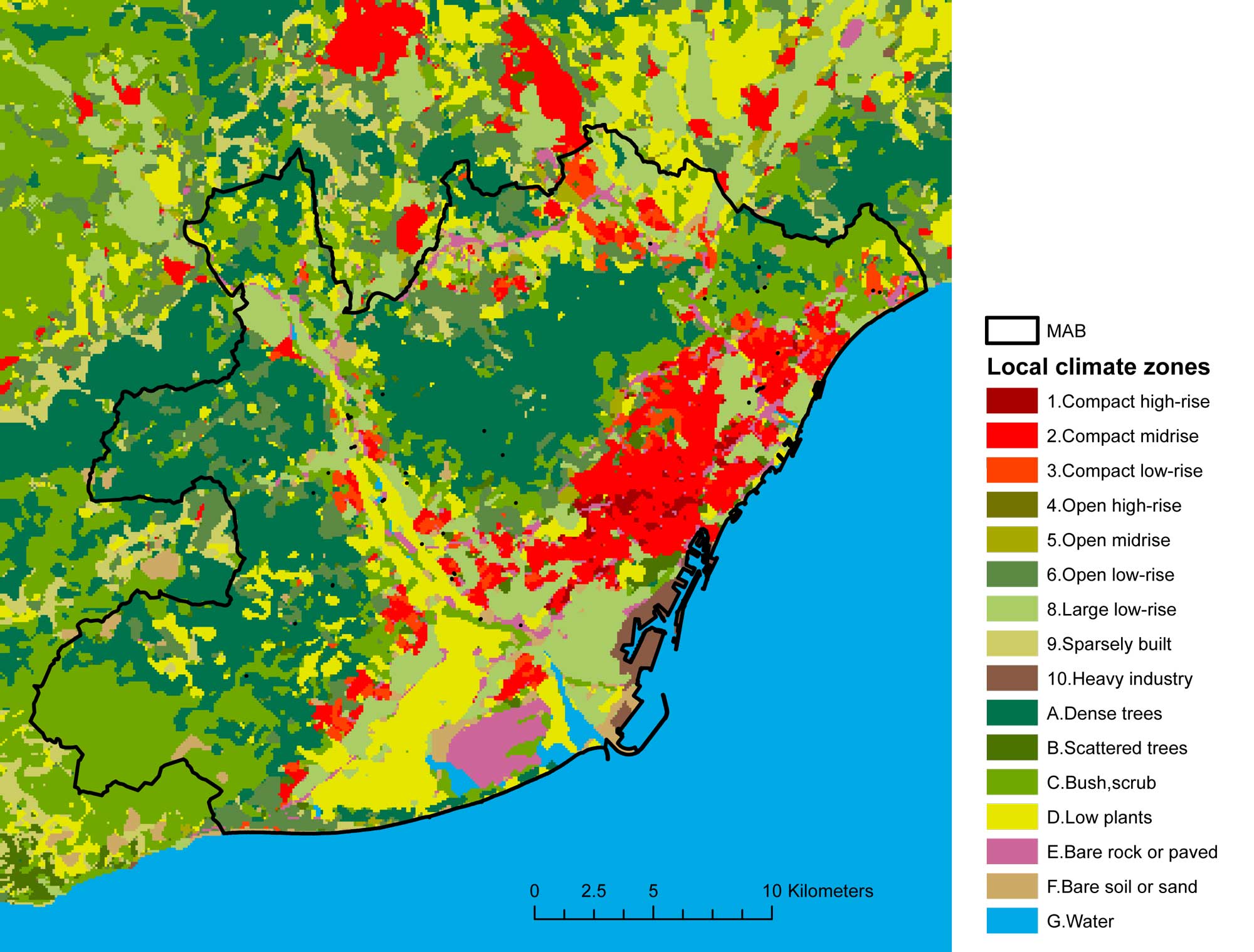
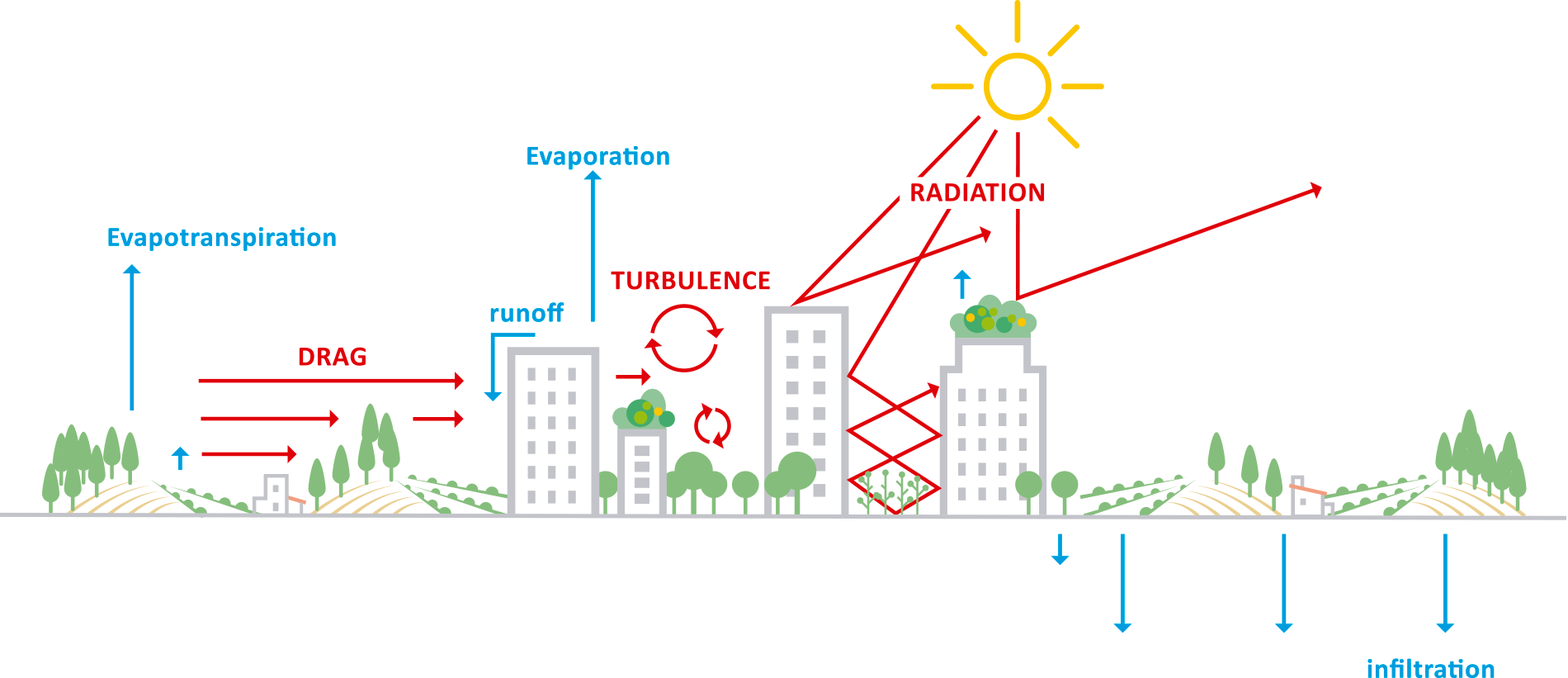
As a second part of this task, the regional and Eulerian weather chemical modeling system WRF-Chem80 will be applied over both cities with the urban canopy model 81 at high-resolution. An innovative spatial disaggregation approach will be created based on land-use and/or local climate zone information to increase the resolution of emissions up to 100m. The WRF-Chem will be run with an urban canopy scheme to capture the changes in humidity and ambient temperature patterns due to increased evapotranspiration from vegetation and modifications on the albedo of urban surface. Such high-resolution land-use allows for a more precise energy budget which considers the height of the building, the turbulence created by street canyons, irrigation of green infrastructures, and the albedo of buildings and green areas.

To constrain the photosynthetic uptake of CO2 by green infrastructures, we will use carbonyl sulfide (OCS) as a tracer. Since OCS is only produced in the oceans and consumed by plants on land, the fact that the two cities are coastal is key in the analysis to determine the OCS drawdown as air masses travel from the sea onto the land. We will take measurements of observed OCS concentrations at various key locations of the urban and peri-urban green infrastructure areas of the two. The expected outcome is to be able to quantify the CO2 uptake of green infrastructures through OCS simulations of the case study city scenarios and demonstrate how the global OCS inventories can be applied to other cities as well.
The team will attempt to answer the following questions: 1) To what extent does the performance of various green infrastructures vary throughout a meteorological year under the same climate condition? 2) What are the most appropriate green infrastructures in terms of air quality, carbon footprint and urban heat island effect? 3) To improve air quality and reduce heat stress in both case studies, where should the green infrastructures be placed: near the emission sources (main road-infrastructures, for instance) or near residential areas?
WP3 Integrated assessment of green infrastructure analysis (RQ3/RO3).
The integrated assessment of green infrastructures will be performed for the two cities by using life cycle analysis and atmospheric modeling, and will incorporate social and policy implications. The team will determine the carbon footprint resulting from the city´s metabolism of food, water, energy and waste management.
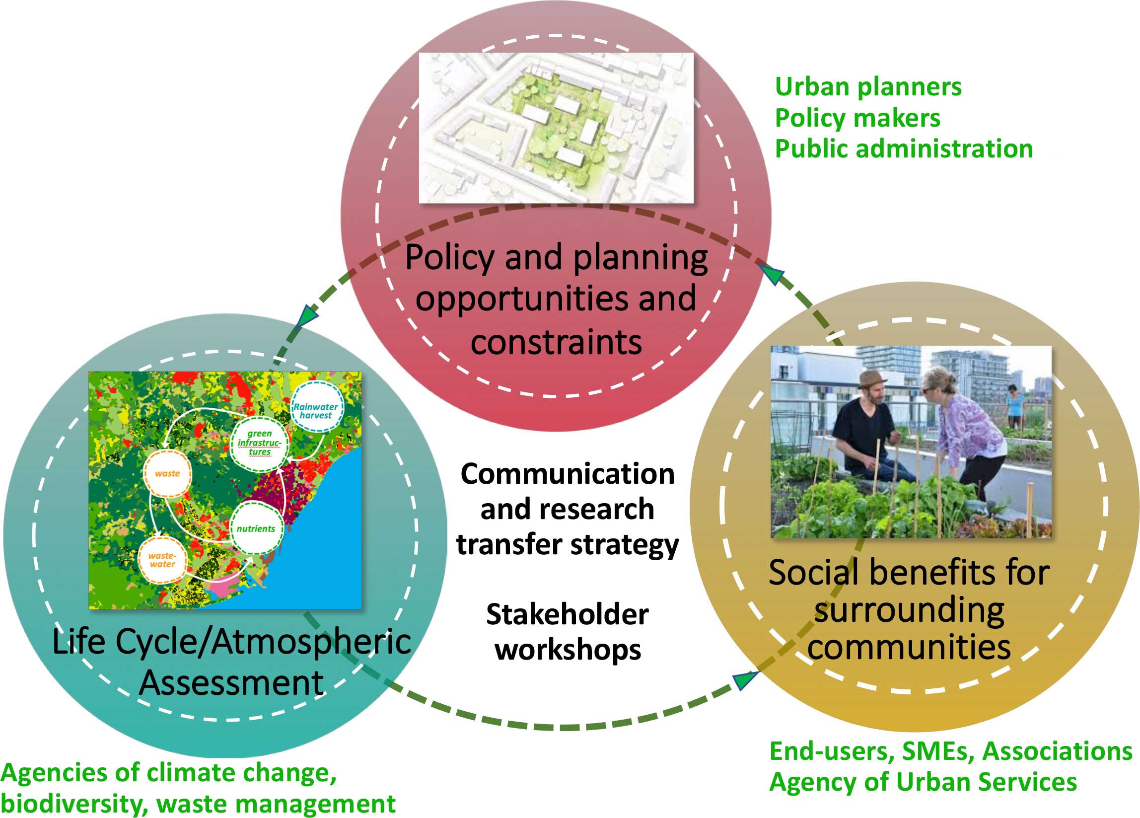
The team will pay particular attention to the policy and planning opportunities and constraints to further develop green spaces and ensure that their benefits are equitably distributed and that the needs, languages, identities, and uses of surrounding residents are considered. Two stakeholder workshops (year 1 and year 4 of project) will help strategize the policies and targets the cities have in place for green infrastructure, carbon footprint reduction, and air quality.

URBAG will have an advisory board to resolve issues in critical moments and assess the quality of the milestones (both identified in table 2). It will have nine members with expertise in each of the main disciplines required by the project:
Chris Kennedy of Victoria University, Canada (urban metabolism), Jo DeWulf of Guent University, Belgium (life cycle analysis), Leonor Tarrason, NILU, Norway (urban emissions and modeling), Josep Anton Morguí, ICTA, Barcelona (observations and measurements), Juan Ignacio Valero, Institute of Agronomy Research, Spain (urban agriculture), Prof. Elliott Campbell from UC Merced, USA (OCS measurements, atmospheric modeling), Ravan Ahmadov of the US National Oceanic and Atmospheric Administration (WRF-Chem developer), Isabelle Anguelovsky (Barcelona Lab for Urban Environmental Justice) and Prof. Robert Ayres (INSEAD).
Barcelona
- Academic/Scientific
- Barcelona Super Computing Center
- Cartographic Institute of Catalunya
- Barcelona Laboratory for Urban Environmental Justice and Sustainability
- LEITAT Technological Center
- IAAC – Institute for Advanced Architecture of Catalonia
- Public
- Area of Ecology, Urban Planning and Mobility
- Area of Ecology of the Metropolitan Area of Barcelona
- Waste Agency of Barcelona
- Aigües de Barcelona (waste water treatment)
- Institute of Regional and Metropolitan Studies of the Barcelona
- Department of Green Spaces, Biodiversity, Environment and Urban services of the city of Barcelona
- Catalan Office for Climate Change
- Environmental services. Sustainability and Territory management
- SMEs
- Campus Estela, ENT environment and Mangement, Sglobal, Materia verda Durán i Grau Architects
- Associations
- Economat Social cooperative
- Environmental association Bosc Turull
Oslo
- Academic/Scientific
- Norwegian Institute for Air Research (NILU)
- NTNU, Trondheim University
- NMBU, University of Norway
- CICERO Center for International Climate Research
- NIVA Norwegian Institute for Water Research
- SMEs
- Growlab
- Tason Microgreens
- BysPire
- Associations
- Oslo Green House
- Non-profit
- Foodstudio
- Kore Foundation
- Public
- Landbruksavdelingen, Fylkesmannen, Oslo og Akershus
- ByKuben, Oslo Kommune